|
Hubbards Area Heritage Collection
|
|
Timeline and History A Brief History of St. Margaret's Bay and the Hubbards area in particular. March 2004 Based on information from: As the Last Leaf Fell, by Barbara Peart. Self-published, 2001 and St. Margaret’s Bay, An Historical Album, Alfreda Withrow, Nimbus/Four East 1997. (All excerpts from St. Margaret's Bay by Alfreda Withrow, published in 1997 by Nimbus Publishing, Ltd are reproduced with consent of the author and publisher, February, 2004. Any other use is strictly prohibited.) Hubbards is located on St. Margaret’s Bay, on the south shore of Nova Scotia. The history of permanent European settlement in the area dates back to around 1785. Hubbards is one of the Shatford Area Trust communities. Click on the underlined text for pictures and/or more information. The blue background of the timeline is from Brenton Homans' painting of Cork Lake. Pre 1600The first people in Nova Scotia and the Bay area were the nomadic Mi’kmaq who have been in the province for thousands of years. They fished and hunted here in the summer and returned inland for the winter. Archeological digs have unearthed arrowheads, clay pots, stone tools and huge piles of shells. The Mi’kmaq continued to set up summer camps here until the early 1900s. Beginning in the 1500s, European fishermen also set up summer camps along the coast of Nova Scotia to dry their catch before heading back across the Atlantic. However the Mi’kmaq were the only permanent inhabitants of this area until the late 1700s.
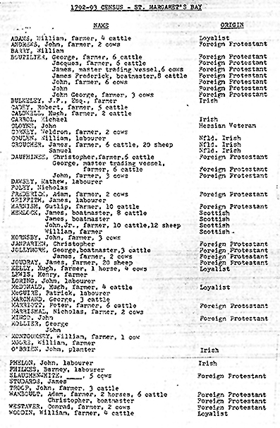
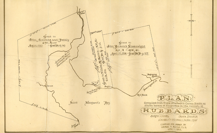
In 1604, France sent Sieur De Monts and Samuel de Champlain with a group to settle “Acadie” which included Nova Scotia. In 1605, they established the first permanent settlement in North America at Port Royal on the opposite side of Nova Scotia. During the 1600s and 1700s, villages, farms and fortresses began appearing along the coast of Nova Scotia. In this area, lasting settlement did not begin until the late 1700s when land grants were given. “By 1761, a few people had come to St. Margaret’s Bay and attempted to settle on the Islands for the sake of the cod and salmon fishery but not a single person stayed here permanently.” Page 7, As the Last Leaf Fell. “However by 1785, we see a growth in population as the first settlers were offered land grants on the condition that they take up permanent residence. Some of the first permanent settlers of the Bay area were the children of Foreign Protestants who had received land grants in Lunenburg County in 1752. Many of these men were farmers and fishermen by trade who wanted to own land and provide food and shelter for their families.” Page 8, St. Margaret’s Bay. Some of these Foreign Protestants were originally from the Montbéliard region of France. Others were from Franconia, now part of Germany and some were Swiss. Many of their surnames such as Boutilier, Coolen, Dorey, Dauphinee, Harnish, Schwartz, Westhaver and Shankel are still evident in the Hubbards area today. “During this same period, there was another influx of Loyalist settlers from the United States. These settlers were granted land in return for their allegiance to the British Crown. In 1793, a poll tax assessment was recorded showing a total 59 families residing in the St. Margaret’s Bay area.” Page 8, St. Margaret’s Bay. An early land grant shows three landowners around Hubbards Cove, the earliest from 1790. Goetlieb Harnish and family were the first settlers.
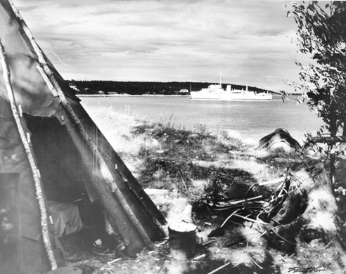
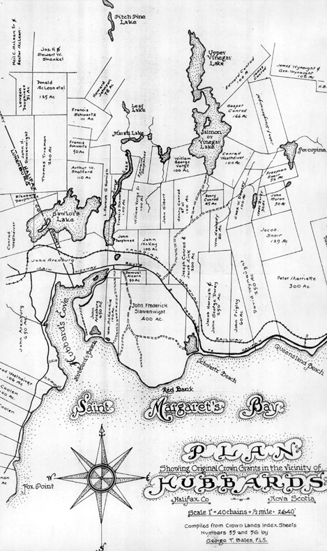
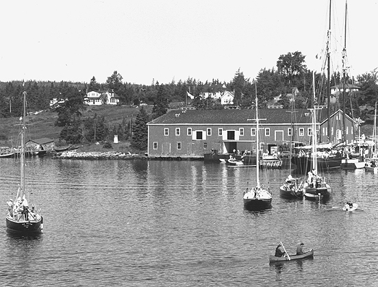
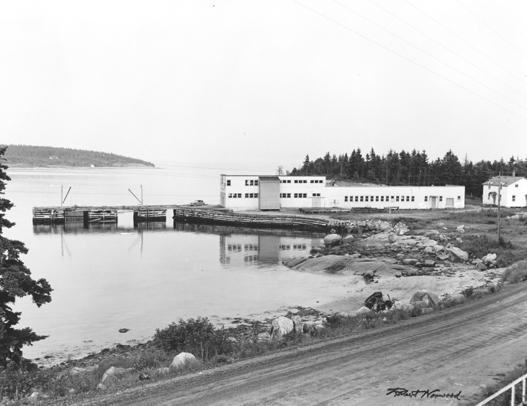
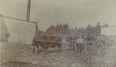
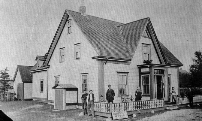
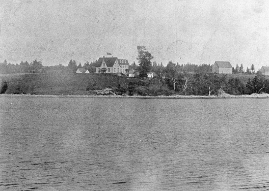
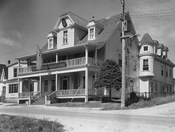
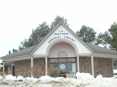
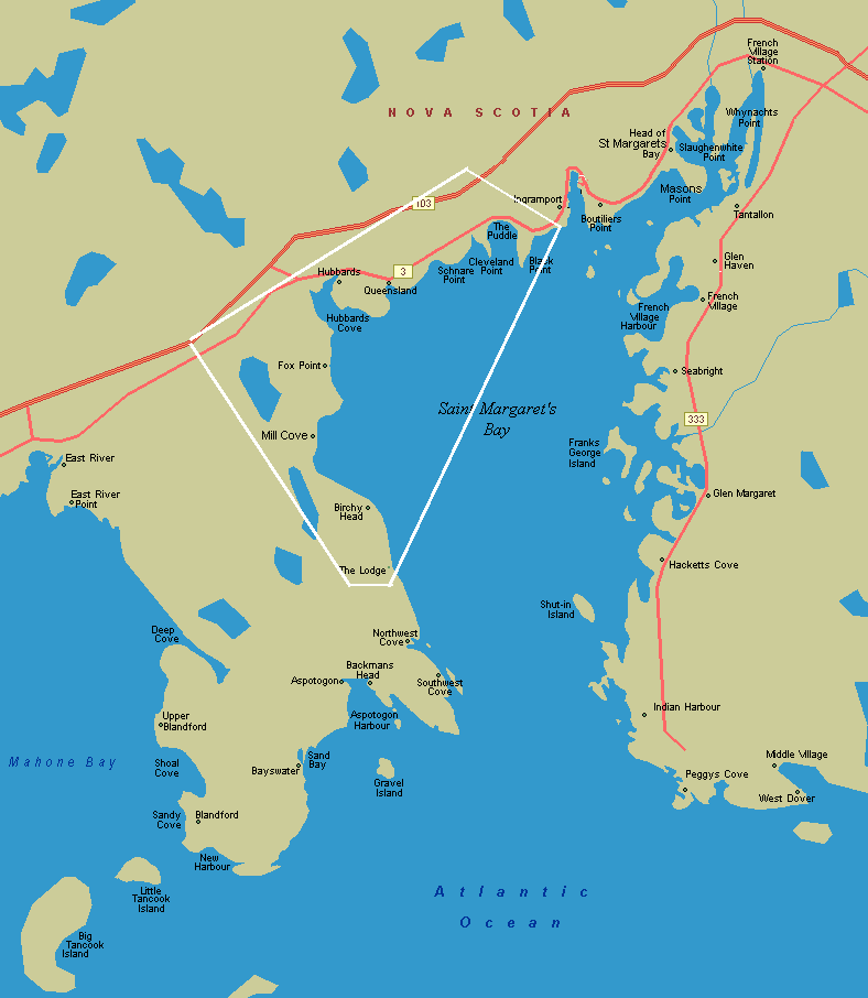
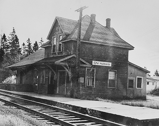
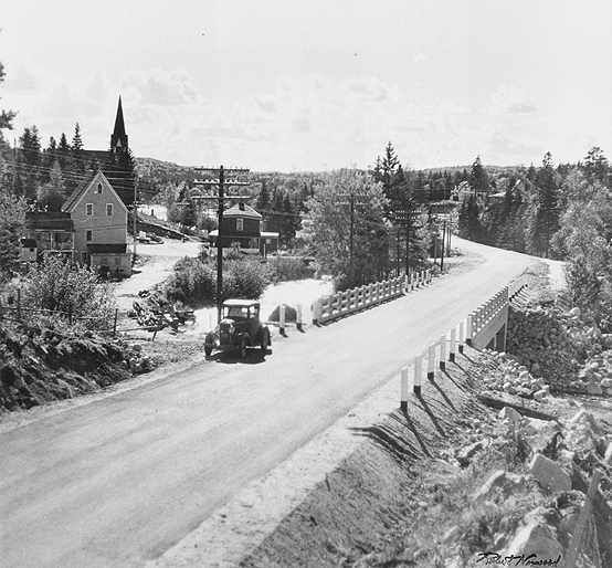
By 1817, the population in the area was 506 people. “It is around this time that the Bay area grew from being a settlement to a number of separate small communities, with the building of proper stores, churches, way stations and school houses. This was a period of steady growth and development. By 1840, there were a total of 161 families living in the area.” Page 8 St. Margaret’s Bay A later map shows many new land grants in the Hubbards area. The St. Margaret’s Bay Road was built between 1840 and 1845 from Armdale to Chester linking all the communities on the Bay. With the road came a coach service. “In 1847, the Royal Western Mail Shore Line stage coach began its biweekly runs which continued until the early 1900s.” Page 9, St. Margaret’s Bay. Fishing was a major industry around the Bay. The Hubbards area had two fish plants: the Burns Fish Plant (built in 1920's and closed in mid 1980's) and the Associated Seafoods plant in Fox Point which operated in the 1940s and 1950s until it burnt down. Shatford Lobster Pound opened in 1949 and residents can still pick up fresh lobster there today. Farming, shipping, and lumbering were also important to the growing economy. In Hubbards village, Shankel’s sawmill ran off the Fitzroy River behind the family home. Tourism increased during the 1800s and Hubbards with its scenic cove and beaches was a popular tourist spot. The Somerset House or McLean House, built in 1853 and used extensively as a stopover for stagecoaches, operated for more than 100 years. It was torn down in 1966 and the current post office erected on the site. The Dauphinee Hotel was built in the late 1800s but burnt down in the 1950s. The Gainsborough Hotel was built next to the McLean House in 1884. It was sold in 1944 to the government and used as part of the St. Margaret’s Bay Training School for the Merchant Marines and for various other businesses after the War. The JD Shatford Library built in 1969 is now on the site. Most communities in the bay area today were formed during this period. This Web site covers the eight communities within the Shatford Trust area: Hubbards, Queensland, Black Point, Simms Settlement, Fox Point, Mill Cove, Birchy Head and The Lodge. See below for historical information on each individual community and how it got its name. This map shows the Shatford Trust area with place names. “It was during the years 1890 to 1910 that St. Margaret’s Bay enjoyed a period of prosperity due to a second building boom.” Page 9 St. Margaret’s Bay. The Halifax South Western Railway between Halifax and Yarmouth was completed in 1905 carrying both passengers and freight. Three railway stations were built in the Bay area including the Hubbards station. “The popularity of this small resort made the railway important for the arrival of visitors during their summer vacations.” Page 71. St. Margaret’s Bay. Cars became more common around the Bay from the 1920s onward. As transportation became easier, people bought or rented cottages in the Bay area including Hubbards and spent summer days at the many beaches. Dances are still held at the Shore Club (opened in 1946) and sailing, canoeing, and rowing were popular. In 1969, Highway 103 was completed linking Hubbards to Halifax with a driving time of about 45 minutes. This meant more residents traveling to the city for work and more visitors from the city and other locales. Hubbards has benefited in recent years from films and TV series being shot in the area and using the former Mill Cove Forces Base for indoor production.
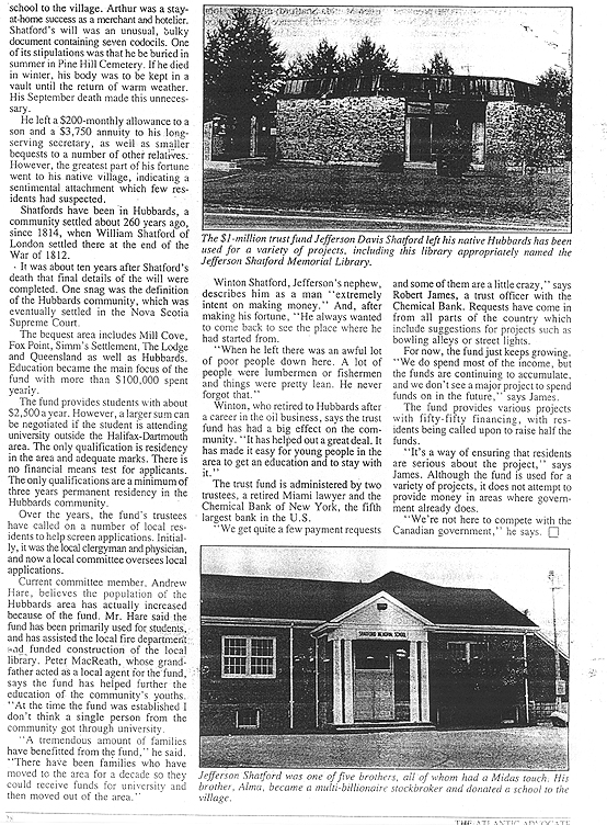
“The communities around St. Margaret’s Bay were originally developed as small fishing villages, which were once isolated and connected only by water. However, as the different modes of travel evolved, many changes began to take place. What was once a road joining together a number of small fishing village, now looks like one very long residential highway with churches, schools, small businesses and modern homes… Today it is difficult to distinguish where one community ends and another begins.” Page 9 St. Margaret’s Bay. Shatford Trust Area CommunitiesFrom Place-Names and Places of Nova Scotia by the Public Archives of Nova Scotia, 1974 edition. page 299: Hubbards The community is located at Hubbards Cove, on the boundary of Halifax and Lunenburg Counties. It is believed the name came from an early settler Hibbert Dauphinee. Hibbert's Beach/Cove later became Hubbard's Cove. The "Cove" was officially dropped in 1905. The first land grant in 1790 for 650 acres to John Arenburg was deeded to Gotlieb Harnisch, a few years later. The corner-stone for St. Luke's Anglican Church was laid 1848, it was not consecrated until 1871. A carillon was installed in 1956 in memory of the Shatford family. A new rectory was constructed in the same year. St. Anthony's Roman Catholic Church was built in 1940. A schoolhouse was built in 1832. A new building was erected about 1899. The Shatford Memorial School was built in 1948. A Postal Way Office was established in December, 1853. The Hubbards Federal Building was completed on April 22, 1966. The corner-stone for the new Fire Hall was laid on November 25, 1961.The railway surveys began in June 1898. The line went into operation in 1904. Jefferson Davis Shatford, a native of Hubbards who became a successful industrialist in the United States, bequeathed the sum of $1,400,000 in trust for religious, charitable or educational purposes. The early settlers took their living from the sea. Fishing for tuna, swordfish and mackerel is still important. Burns Fisheries operated a fish processing plant and there was a fish chowder factory as well. Norma and Company Ltd., margarine manufactures began operation in February, 1950. Shankel and Freeman began lumbering operations about 1869, and the village boomed for awhile. Railroad and automobile travel brought summer visitors to stay at hotels and cottages. In the years following World War ll, Metro moved to Hubbards and commuting to and from Halifax Dartmouth began. The population in 1956 was 418.
page 567: Queensland A community located about two miles east of Hubbards on the south shore of Nova Scotia. Johann Frederick Schlagentweid obtained a 100 acre land grant in April, 1814. Further land grants of 250 acres and 60 acres were made to Jacob Harnisch in partnership with John Dorey and John Prigley, respectively. St. Mark's United Church was dedicated in June ,1892 as a Methodist Church. Extensive beaches and scenic surroundings have made it into a summer resort area. The population in 1956 was 338.
page 69: Black Point Located on the west side of the mouth of Head Harbour, St. Margaret's Bay. The original grantees were Alexander Stewart with 500 acres in October 1786 and George Jollimore, who had been settled for five years before receiving his grant of 500 acres November 1820. A school was opened in 1879 and another new school in 1901. In 1956, construction was begun on a four room primary school with completion in 1957. A Postal Way Office was established on August 1, 1867. James Hubley was the postmaster. The United Baptist Church was dedicated on October 9, 1898. Employment in the Metro area, some fishing, a bakery and a small factory for pre-fabricated homes kept the population of 273 in 1956 working.
Simms Settlement
Simms Settlement is located at 44°37'41"N, 64°05'17"W ,
St. Margaret's Bay, Lunenburg county. page 219: Fox Point Located two miles south of Hubbards on the western side of St. Margaret's Bay. Mr. Shatford the father of John E. Shatford settled here soon after 1812. Patrick Noonan took possession of land here in 1832. A schoolmaster, James MacRae was here by 1846 with a school built in 1876. St. James' Anglican Church was built 1909-10. A Seventh Day Adventist Church was completed in July of 1954 and dedicated June 19, 1955. Fishing and farming were the main industries, with a fish company constructed about 1948. Population in 1956 was 280.
page 439 Mill Cove It is approximately four miles south of Hubbards on the western side of St. Margaret's Bay. A one thousand acre grant of land to James Jollymore and John Troop in 1832 began the settlement. James MacRae in 1845, was one of the earliest teachers, a school was built in 1878. A new four room elementary school was opened in December , 1956. A Postal Way Office was established in 1865. The Naval Communication Centre was constructed in 1966. Fishing and farming are the main industries. In 1956 the population was 231. page 68: Birchy Head Situated five miles south of Hubbards on the western side of St. Margaret's Bay. The first land grant of 250 acres was received by George Young in 1828. Fishing was the main industry, the population in 1956 was 63.
The Lodge The
Lodge is located at 44°33'22"N, 64°01'55"W in St. Margaret's Bay Lunenburg
county. |